
படிமம்:India Karnataka location map.svg

Size of this PNG preview of this SVG file: 423 × 600 படப்புள்ளிகள். மற்ற பிரிதிறன்கள்: 169 × 240 படப்புள்ளிகள் | 338 × 480 படப்புள்ளிகள் | 542 × 768 படப்புள்ளிகள் | 722 × 1,024 படப்புள்ளிகள் | 1,445 × 2,048 படப்புள்ளிகள் | 898 × 1,273 படப்புள்ளிகள் .
மூலக்கோப்பு (SVG கோப்பு, பெயரளவில் 898 × 1,273 பிக்சல்கள், கோப்பு அளவு: 759 KB)
| இது விக்கிமீடியா பொதுக்கோப்பகத்தில் இருக்கும் ஒரு கோப்பாகும். இக்கோப்பைக் குறித்து அங்கே காணப்படும் படிம விளக்கப் பக்கத்தை இங்கே கீழே காணலாம்.
|
| விளக்கம் |
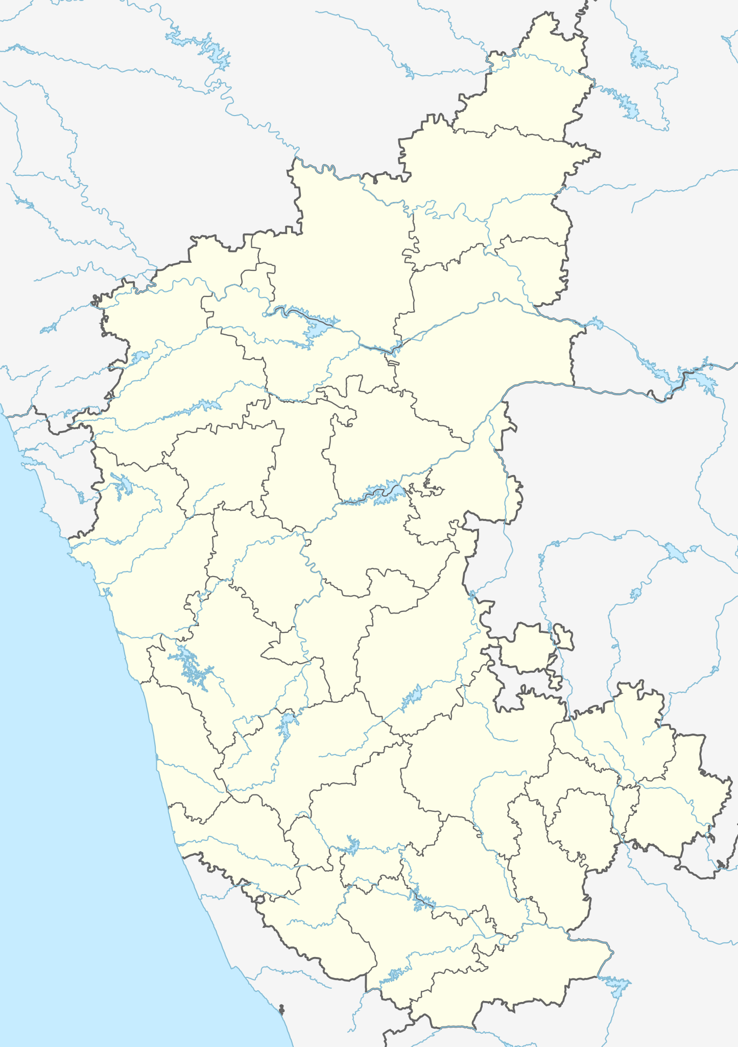
Location map of Karnataka Geographic limits of the map:
|
| நாள் | (UTC) |
| மூலம் | |
| ஆசிரியர் |
|
| ஒத்தக்கோப்பு |
Derivative works of this file: |
| இது ஒரு திருத்தப்பட்ட படிமமாகும், அதாவது இதன் மூல வடிவத்திலிருந்து கணினி மூலம் இதில் மாற்றங்கள் செய்யப்பட்டுள்ளது. திருத்தங்கள்: Created 3 new districts Chikkaballapur, Ramanagara and Yadgir. Changed conventions per WP:WPMAP. மூலக்கோப்பை இங்கு காணலாம்: Karnataka locator map.svg. திருத்தங்களைச் செய்தவர் Nayvik.
|
இந்த கோப்பு Creative Commons Attribution-Share Alike 3.0 Unported உரிமத்தின் கீழ் உள்ளது.
- நீங்கள் சுதந்திரமாக:
- பகிர்ந்து கொள்ள – வேலையை நகலெடுக்க, விநியோகிக்க மற்றும் அனுப்ப
- மீண்டும் கலக்க – வேலைக்கு பழகிக்கொள்ள.
- கீழ்க்காணும் விதிகளுக்கு ஏற்ப,
- பண்புக்கூறுகள் – நீங்கள் பொருத்தமான உரிமையை வழங்க வேண்டும், உரிமத்திற்கான இணைப்பை வழங்க வேண்டும் மற்றும் மாற்றங்கள் செய்யப்பட்டிருந்தால் குறிப்பிட வேண்டும். நீங்கள் ஏற்புடைய எந்த முறையிலும் அவ்வாறு செய்யலாம், ஆனால் எந்த வகையிலும் உரிமதாரர் உங்களை அல்லது உங்கள் பயன்பாட்டிற்கு ஒப்புதல் அளிக்கும் படி பரிந்துரைக்க கூடாது.
- அதே மாதிரி பகிர் – நீங்கள் ரீமிக்ஸ் செய்தாலோ, உருமாற்றம் செய்தாலோ அல்லது பொருளை உருவாக்கினாலோ, உங்கள் பங்களிப்புகளை அல்லது இணக்கமான உரிமம் கீழ் அசலாக விநியோகிக்க வேண்டும்.
Original upload log
This image is a derivative work of the following images:
- File:Karnataka_locator_map.svg licensed with Cc-by-sa-3.0
- 2007-05-06T13:55:02Z Planemad 1630x2356 (231773 Bytes) {{WikiProject_India_Maps |Title=Karnataka locator Map |Description=Map of [[w:Karnataka]] with road and rail lines |Source= [http://aquarium.lipetsk.ru/discovery/India2004/karnataka-map.jpg Karnataka Map], [http://www.indianr
Uploaded with derivativeFX
கோப்பின் வரலாறு
குறித்த நேரத்தில் இருந்த படிமத்தைப் பார்க்க அந்நேரத்தின் மீது சொடுக்கவும்.
| நாள்/நேரம் | நகம் அளவு சிறுபடம் | அளவுகள் | பயனர் | கருத்து | |
|---|---|---|---|---|---|
| தற்போதைய | 03:10, 16 சூன் 2023 | | 898 × 1,273 (759 KB) | C1MM | c Vijayanagara district |
| 04:41, 13 ஆகத்து 2021 |  | 851 × 1,211 (582 KB) | C1MM | Added more rivers | |
| 03:33, 16 சூலை 2021 |  | 851 × 1,211 (561 KB) | C1MM | Added more accurate district boundaries | |
| 23:41, 14 திசம்பர் 2020 |  | 1,634 × 2,367 (341 KB) | C1MM | Fixed boundaries of Vijayanagara district | |
| 22:10, 14 திசம்பர் 2020 |  | 1,634 × 2,367 (345 KB) | C1MM | Added boundaries of AP/Telangana and rivers | |
| 19:26, 13 திசம்பர் 2020 |  | 1,634 × 2,367 (342 KB) | C1MM | Fixed district boundaries of Ballari and added Vijayanagara district | |
| 03:53, 21 ஏப்பிரல் 2020 |  | 1,634 × 2,367 (289 KB) | C1MM | Added rivers | |
| 15:50, 15 நவம்பர் 2010 |  | 1,630 × 2,356 (207 KB) | Nayvik | Changed background color | |
| 15:34, 15 நவம்பர் 2010 |  | 1,630 × 2,356 (206 KB) | Nayvik | {{Information |Description=Location map of Karnataka Geographic limits of the map: * 18.5°N * 11.0°N * 73.6°E * 78.7°E |Source=*File:Karnataka_locator_map.svg, [http://www.censusindia.gov.in/2011-Images/ADMINI2011.jpg Census In |
கோப்பு பயன்பாடு
100 க்கும் மேற்பட்ட பக்கத்தின் இணைப்பு இந்த கோப்பிற்கு உள்ளது.
கீழ்கண்ட பட்டியல் காட்டுவது, முதல் 100 பக்க இணைப்புகளை பக்கம், இந்த கோப்பிற்கு மட்டும். ஒரு முழு பட்டியல் உள்ளது.
- 1991 தமிழருக்கெதிரான கருநாடகக் கலவரம்
- அட்டிவேரி பறவைகள் சரணாலயம்
- அன்கோலா
- அரசிகெரே
- அரப்பனள்ளி
- இட்டகி மகாதேவர் கோயில்
- இலட்சுமிகாந்தன் கோயில், கலாலே.
- இலட்சுமேசுவரம்
- ஈரா, தட்சிணா கன்னடம்
- உடுப்பி
- எலபர்கா
- ஏ. உப்பரகாளி
- ஏ. வியபலபாலி
- ஒசகோட்டே
- ஒன்னாலி
- ஒறநாடு
- கங்காவதி, கர்நாடகா
- கனககிரி
- கனகபுரா
- கபு, கருநாடகம்
- கருநாடகம்
- கர்கலா
- கல்கட்டி அருவி
- கல்லட்டி அருவி
- காவேரி காட்டுயிர் புகலிடம்
- கின்னிகோலி
- குக்கனூர்
- குக்கி சுப்பிரமணியசுவாமி கோயில்
- குஞ்சா நரசிம்ம சுவாமி கோயில், திருமாக்கூடல் நரசிபுரம்
- குடவி பறவைகள் சரணாலயம்
- குந்தோல்
- கும்டா
- குல்பர்கா கோட்டை
- கூடிளி
- கோனிகொப்பால்
- சன்னதி
- சரபாடி
- சலசங்வி ஈசுவரன் கோயில்
- சாமுண்டீஸ்வரி கோயில்
- சித்திரதுர்க்கா கோட்டை
- சித்லகட்டா
- சிறீரங்கப்பட்டணக் கோட்டை
- சிவன் கோயில், நாராயணாபுரம்
- சுப்ரமண்யா, கர்நாடகா
- சுவாமி விவேகானந்தா கோளரங்கம்
- சென்னகிரி
- சென்னகேசவர் கோயில், சோமநாதபுரம்
- சோமநாதபுரம் (கர்நாடகம்)
- ஜலசங்வி
- ஜலதுர்கா
- தனரகி
- தரிகெரே
- தர்மசாலா கோயில்
- தர்மஸ்தலா
- தோடிகானா
- நந்தி மலை
- நாகர்ஹோளே தேசிய பூங்கா
- நாட்டுப்புறவியல் அருங்காட்சியகம், மைசூர்
- பசவகல்யாணக் கோட்டை
- பட்டடக்கல்
- பத்ரா வனவிலங்கு சரணாலயம்
- பத்ராவதி, கர்நாடகா
- பனவாசி
- பன்னேருகட்டா தேசியப் பூங்கா
- பயலாலு
- பாகல்கோட்டை
- பாதமி
- பிஜப்பூர் கோட்டை
- பீதர் கோட்டை
- புத்த விகாரை, குல்பர்கா
- புனாச்சா
- புனித மேரித் தீவுகள்
- பெங்களூர்
- பெலவாடி
- பெல்லாரி அனல் மின் நிலையம்
- பொன்னம்பேட்டை
- மகதி பறவைகள் சரணாலயம்
- மகாகூடக் கோயில்கள்
- மங்களூரு பன்னாட்டு வானூர்தி நிலையம்
- மங்களூர்
- மத்தூர், மண்டியா
- மள்ளாலி அருவி
- மாத்தூர், சிமோகா மாவட்டம்
- முத்கல்
- முன்னூரு
- மூதபித்ரி
- மைசூர் விமான நிலையம்
- யானா, இந்தியா
- யோகநரசிம்மர் கோயில், தேவராயனதுர்கம்
- ரங்கன்திட்டு பறவைகள் காப்பகம்
- ரபகவி
- லாட்கான் கோயில்
- வாடி, கர்நாடகா
- விருபாட்சர் கோயில்
- வீரநாராயணர் கோயில்
- வேணுகோபாலசுவாமி கோயில், தேவனஹல்லி
- ஹட்டிகுனி
- ஹரிகர்
- ஹூப்ளி
- ஹூப்ளி விமான நிலையம்
இந்த கோப்பிற்கான அதிக இணைப்புகளை பார்.
கோப்பின் முழுமையான பயன்பாடு
கீழ்கண்ட மற்ற விக்கிகள் இந்த கோப்பை பயன்படுத்துகின்றன:
- ar.wikipedia.org-திட்டத்தில் இதன் பயன்பாடு
- as.wikipedia.org-திட்டத்தில் இதன் பயன்பாடு
- azb.wikipedia.org-திட்டத்தில் இதன் பயன்பாடு
- تومکور
- بنقلور
- عباسی، کارناتاکا
- اودقولام
- پیکلیهال
- اوداجی (هیندوستان)
- اوچیلا, اودوپی دیستریکت
- اوچاواد
- او خاناپور
- ویراهانوماکاناپالیا
- فاجیر (هیندوستان)
- پتالور (هیندوستان)
- پت آماپور
- ویراکامبا
- ویراپور
- وانور (هیندوستان)
- ساتیجری
- ساتانور, ماقادی
- ساتانور, بانقالور
- ساسالاتی
- سارقور
- ساراواد
- ساراپادی
- ساپتاساقار
- سانتور
- سانتکاسالاجر
- مایاکوندا
- ساناتی
- ماویناکر
- ماوالی
- ماتیواد
- کالادکا
- سانیکاتا
- کالکونت
- کالکری
- ماتماری
- سانقاناهالا
- کالجی (هیندوستان)
- سانقامشوارا, کالاقاتاجی
- ماتاداکوروباراهاتی
- ماستیهولی
- کالاسا, کوندقول
- ماسارکال
- ماسابینال
சிறப்பு பக்கம்-மொத்த பயன்பாடு - இதன் மூலம் இந்த கோப்பின் மொத்த பயன்பாட்டை அறிய முடியும்