
படிமம்:Hms arethusa map.png
இந்த முன்னோட்டத்தின் அளவு: 800 × 541 படப்புள்ளிகள் . மற்ற பிரிதிறன்கள்: 320 × 216 படப்புள்ளிகள் | 640 × 433 படப்புள்ளிகள் | 1,024 × 692 படப்புள்ளிகள் | 1,498 × 1,013 படப்புள்ளிகள் .
மூலக்கோப்பு (1,498 × 1,013 படவணுக்கள், கோப்பின் அளவு: 2.27 MB, MIME வகை: image/png)
| இது விக்கிமீடியா பொதுக்கோப்பகத்தில் இருக்கும் ஒரு கோப்பாகும். இக்கோப்பைக் குறித்து அங்கே காணப்படும் படிம விளக்கப் பக்கத்தை இங்கே கீழே காணலாம்.
|
சுருக்கம்
| Description |
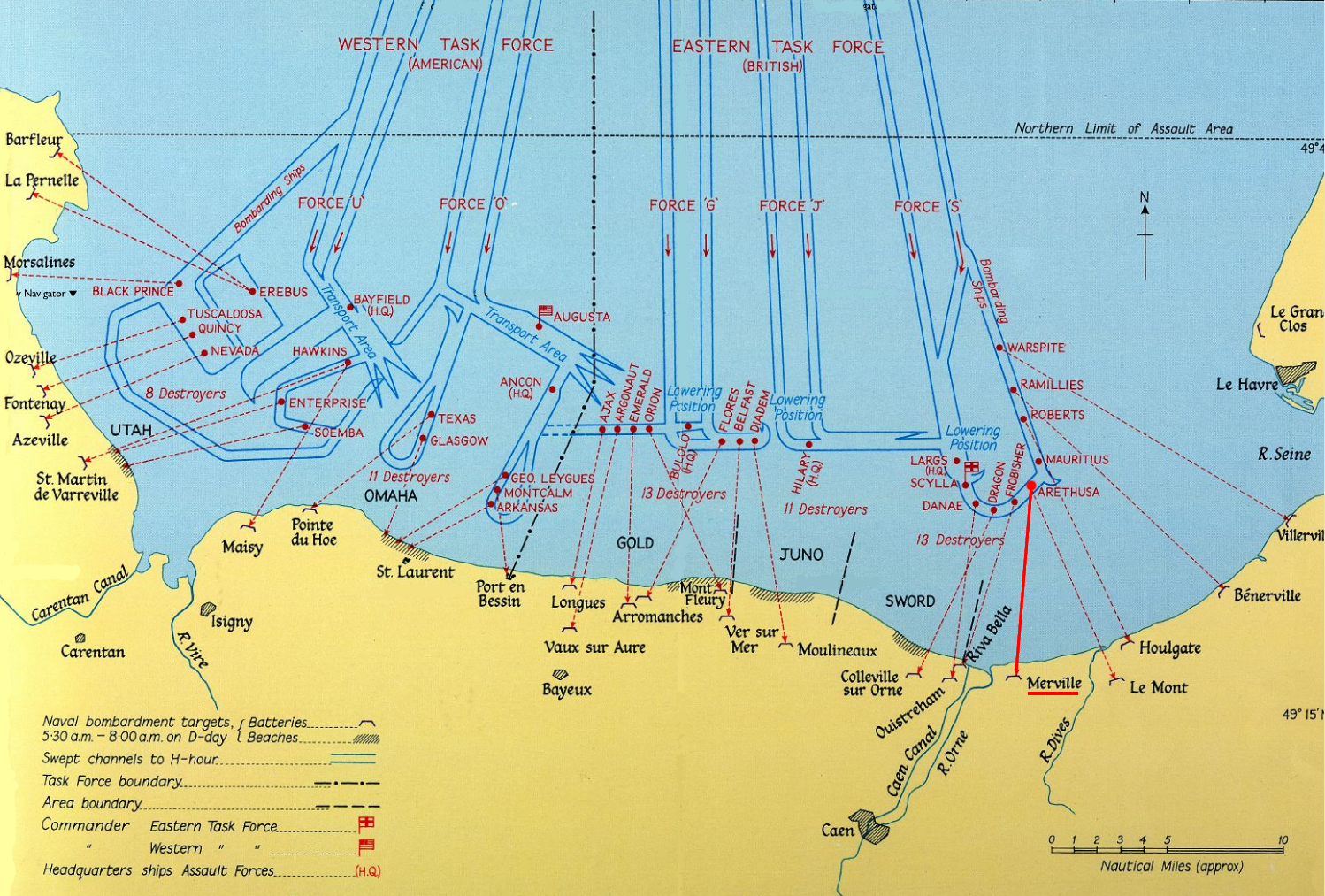
Based on Image:Naval Bombardments on D-Day.png - HMS Arethusa and Merville marked. |
|||||||||
| நாள் | circa 1944 | |||||||||
| மூலம் | http://www.nationalarchives.gov.uk/battles/dday/popup/naval.htm | |||||||||
| படைப்பாளி |
HM Government. Post-Work: User:W.wolny |
|||||||||
| அனுமதி (இக்கோப்பை மீண்டும் பயன்படுத்துதல்) |
|
|||||||||
| Geotemporal data | ||||||||||
| Map location | Normandy | |||||||||
| Bounding box |
|
|||||||||
| Georeferencing | ||||||||||

கோப்பின் வரலாறு
குறித்த நேரத்தில் இருந்த படிமத்தைப் பார்க்க அந்நேரத்தின் மீது சொடுக்கவும்.
| நாள்/நேரம் | நகம் அளவு சிறுபடம் | அளவுகள் | பயனர் | கருத்து | |
|---|---|---|---|---|---|
| தற்போதைய | 17:59, 17 சூலை 2005 | | 1,498 × 1,013 (2.27 MB) | John N. | Auf eine alte Version zurückgesetzt |
| 17:50, 17 சூலை 2005 |  | 1,000 × 1,938 (1.88 MB) | John N. | ||
| 17:40, 17 சூலை 2005 |  | 1,498 × 1,013 (2.27 MB) | John N. | Image:Naval Bombardments on D-Day.png - HMS Arethusa and Merville marked. Licence: Same like Image above |
கோப்பு பயன்பாடு
பின்வரும் பக்க இணைப்புகள் இப் படிமத்துக்கு இணைக்கபட்டுள்ளது(ளன):
கோப்பின் முழுமையான பயன்பாடு
கீழ்கண்ட மற்ற விக்கிகள் இந்த கோப்பை பயன்படுத்துகின்றன:
- br.wikipedia.org-திட்டத்தில் இதன் பயன்பாடு
- ca.wikipedia.org-திட்டத்தில் இதன் பயன்பாடு
- cs.wikipedia.org-திட்டத்தில் இதன் பயன்பாடு
- de.wikipedia.org-திட்டத்தில் இதன் பயன்பாடு
- de.wikibooks.org-திட்டத்தில் இதன் பயன்பாடு
- en.wikipedia.org-திட்டத்தில் இதன் பயன்பாடு
- et.wikipedia.org-திட்டத்தில் இதன் பயன்பாடு
- fi.wikipedia.org-திட்டத்தில் இதன் பயன்பாடு
- fr.wikipedia.org-திட்டத்தில் இதன் பயன்பாடு
- it.wikipedia.org-திட்டத்தில் இதன் பயன்பாடு
- ja.wikipedia.org-திட்டத்தில் இதன் பயன்பாடு
- oc.wikipedia.org-திட்டத்தில் இதன் பயன்பாடு
- ru.wikipedia.org-திட்டத்தில் இதன் பயன்பாடு
- uk.wikipedia.org-திட்டத்தில் இதன் பயன்பாடு
- vi.wikipedia.org-திட்டத்தில் இதன் பயன்பாடு