
படிமம்:Han map.jpg
மூலக்கோப்பு (850 × 550 படவணுக்கள், கோப்பின் அளவு: 151 KB, MIME வகை: image/jpeg)
| இது விக்கிமீடியா பொதுக்கோப்பகத்தில் இருக்கும் ஒரு கோப்பாகும். இக்கோப்பைக் குறித்து அங்கே காணப்படும் படிம விளக்கப் பக்கத்தை இங்கே கீழே காணலாம்.
|
| விளக்கம் |
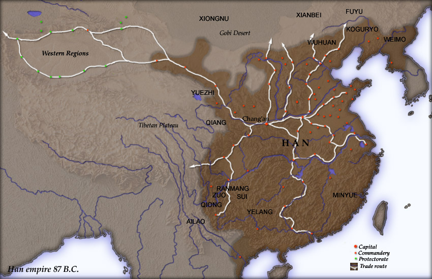
Map of en:Han Dynasty empire 87 BC, showing the capital en:Chang'an and the location of all en:commandery seats. In the Western Regions, a number of pretectorates were Han vassals and under the nominal authority of the Chief Protector of the Western Regions appointed by the Han court. en:Category:Maps of the history of China |
| மூலம் | Created and copyright (2004) by Yuninjie. Released under the GNU FDL. The northern border is the line of the en:Qin Dynasty en:Great Wall. Trade routes are generally based on the work of en:Joseph Needham. Selected non-Chinese peoples are also shown. |
| ஆசிரியர் | User Yuninjie on en.wikipedia |
| அனுமதி (இக்கோப்பை மீண்டும் பயன்படுத்துதல்) |
Released under the GNU Free Documentation License. |
| ஒத்தக்கோப்பு |
Originally from en.wikipedia; description page is (was) here * 00:02, 6 November 2004 [[:en:User:Yuninjie|Yuninjie]] 850×550 (154,737 bytes) <span class="comment">(Map of Han empire 87 BC)</span> |

|
GNU Free Documentation License விதிமுறைகளின் கீழ் இந்த ஆவணத்தை நகலெடுக்க, விநியோகிக்க மற்றும்/அல்லது மாற்றுவதற்கு அனுமதி வழங்கப்பட்டுள்ளது, Free Software Foundation;ஆல் வெளியிடப்பட்ட பதிப்பு 1.2 அல்லது அதற்குப் பிந்தைய பதிப்பு, மாற்றமில்லாத பிரிவுகள், முன் அட்டை உரைகள் மற்றும் பின் அட்டை உரைகள் இல்லாமல் வெளியிடப்பட்டது. GNU Free Documentation License என்ற தலைப்பில் உரிமத்தின் நகல் சேர்க்கப்பட்டுள்ளது. |
| இந்த கோப்பு Creative Commons Attribution-Share Alike 3.0 Unported உரிமத்தின் கீழ் உள்ளது. | ||
| ||
| This licensing tag was added to this file as part of the GFDL licensing update. |
(Uploaded using CommonsHelper or PushForCommons)


கோப்பின் வரலாறு
குறித்த நேரத்தில் இருந்த படிமத்தைப் பார்க்க அந்நேரத்தின் மீது சொடுக்கவும்.
| நாள்/நேரம் | நகம் அளவு சிறுபடம் | அளவுகள் | பயனர் | கருத்து | |
|---|---|---|---|---|---|
| தற்போதைய | 09:16, 2 நவம்பர் 2006 | | 850 × 550 (151 KB) | Shizhao | {{Information| |Description= Map of en:Han Dynasty empire 87 BC, showing the capital en:Chang'an and the location of all en:commandery seats. In the Western Regions, a number of pretectorates were Han vassals and under the nominal authority |
கோப்பு பயன்பாடு
பின்வரும் பக்க இணைப்புகள் இப் படிமத்துக்கு இணைக்கபட்டுள்ளது(ளன):
கோப்பின் முழுமையான பயன்பாடு
கீழ்கண்ட மற்ற விக்கிகள் இந்த கோப்பை பயன்படுத்துகின்றன:
- af.wikipedia.org-திட்டத்தில் இதன் பயன்பாடு
- ar.wikipedia.org-திட்டத்தில் இதன் பயன்பாடு
- arz.wikipedia.org-திட்டத்தில் இதன் பயன்பாடு
- ast.wikipedia.org-திட்டத்தில் இதன் பயன்பாடு
- azb.wikipedia.org-திட்டத்தில் இதன் பயன்பாடு
- ba.wikipedia.org-திட்டத்தில் இதன் பயன்பாடு
- bg.wikipedia.org-திட்டத்தில் இதன் பயன்பாடு
- bn.wikipedia.org-திட்டத்தில் இதன் பயன்பாடு
- bo.wikipedia.org-திட்டத்தில் இதன் பயன்பாடு
- br.wikipedia.org-திட்டத்தில் இதன் பயன்பாடு
- bs.wikipedia.org-திட்டத்தில் இதன் பயன்பாடு
- ca.wikipedia.org-திட்டத்தில் இதன் பயன்பாடு
- ckb.wikipedia.org-திட்டத்தில் இதன் பயன்பாடு
- cs.wikipedia.org-திட்டத்தில் இதன் பயன்பாடு
- cy.wikipedia.org-திட்டத்தில் இதன் பயன்பாடு
- da.wikipedia.org-திட்டத்தில் இதன் பயன்பாடு
- el.wikipedia.org-திட்டத்தில் இதன் பயன்பாடு
- en.wikipedia.org-திட்டத்தில் இதன் பயன்பாடு
- 87 BC
- Colonies in antiquity
- Foreign relations of imperial China
- Wuhuan
- List of conflicts in Asia
- User:Sigurd Dragon Slayer
- User:Kraj35
- User:Ixnix
- User:UBX/Han Empire
- User:Boris1601050607
- User:Merlynne6
- User:Vasko Kelich
- User:Peaceingalaxy
- User:Alam567
- User:OsmanElite
- User:Tarique012
- User:Rexcactorum
- Portal:Asia/Featured article
- Portal:Asia/Featured article/7
- User:允乔
சிறப்பு பக்கம்-மொத்த பயன்பாடு - இதன் மூலம் இந்த கோப்பின் மொத்த பயன்பாட்டை அறிய முடியும்