
படிமம்:Coord LatLong.svg

Size of this PNG preview of this SVG file: 360 × 360 படப்புள்ளிகள். மற்ற பிரிதிறன்கள்: 240 × 240 படப்புள்ளிகள் | 480 × 480 படப்புள்ளிகள் | 768 × 768 படப்புள்ளிகள் | 1,024 × 1,024 படப்புள்ளிகள் | 2,048 × 2,048 படப்புள்ளிகள் .
மூலக்கோப்பு (SVG கோப்பு, பெயரளவில் 360 × 360 பிக்சல்கள், கோப்பு அளவு: 5 KB)
| இது விக்கிமீடியா பொதுக்கோப்பகத்தில் இருக்கும் ஒரு கோப்பாகும். இக்கோப்பைக் குறித்து அங்கே காணப்படும் படிம விளக்கப் பக்கத்தை இங்கே கீழே காணலாம்.
|
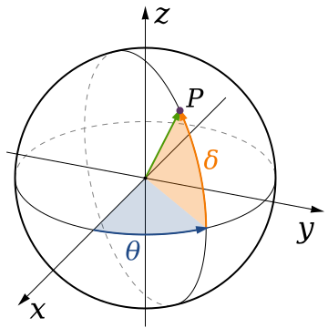
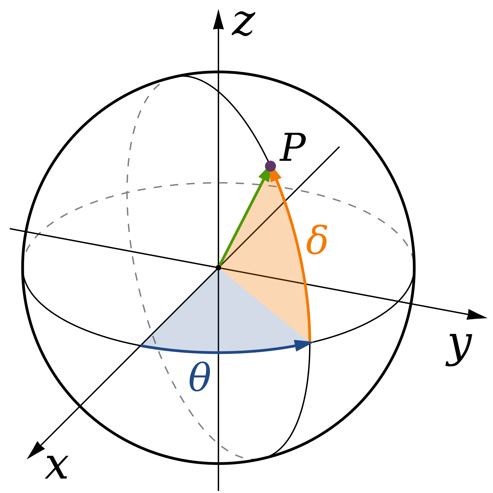
| விளக்கம் | A diagram of spherical coordinates, defining a point by colatitude, φ, longitude, θ, and radius, ρ. |
| நாள் | (UTC) |
| மூலம் | |
| ஆசிரியர் |
|
.svg)
இந்த ஆக்கத்தின் காப்புரிமையாளரான நான் இதனைப் பின்வரும் உரிமத்தின் கீழ் வெளியிடுகின்றேன்:
| I, the copyright holder of this work, release this work into the public domain. This applies worldwide. சில நாடுகளில் இது சாத்தியமில்லாது போகலாம். அவ்வாறாயின் : I grant anyone the right to use this work for any purpose, without any conditions, unless such conditions are required by law. |
Original upload log
This image is a derivative work of the following images:
- File:Spherical_Coordinates_(Colatitude,_Longitude).svg licensed with PD-self
- 2008-04-07T01:57:46Z Inductiveload 360x360 (21703 Bytes) {{Information |Description= |Source= |Date= |Author= |Permission= |other_versions= }}
- 2008-04-07T01:48:21Z Inductiveload 360x360 (21052 Bytes) {{Information |Description= |Source= |Date= |Author= |Permission= |other_versions= }}
- 2008-04-07T01:36:38Z Inductiveload 360x360 (21039 Bytes) {{Information |Description=A diagram of spherical coordinates, defining a point by colatitude, ''φ'', longitude, ''θ'', and radius, ''ρ''. |Source=self-made |Date=08/04/2008 |Author= [[User:Inductiveload|Inducti
Uploaded with derivativeFX
கோப்பின் வரலாறு
குறித்த நேரத்தில் இருந்த படிமத்தைப் பார்க்க அந்நேரத்தின் மீது சொடுக்கவும்.
| நாள்/நேரம் | நகம் அளவு சிறுபடம் | அளவுகள் | பயனர் | கருத்து | |
|---|---|---|---|---|---|
| தற்போதைய | 20:50, 4 செப்டெம்பர் 2019 | | 360 × 360 (5 KB) | Geek3 | Orthographic projection |
| 17:52, 7 ஆகத்து 2009 |  | 360 × 360 (20 KB) | Andeggs~commonswiki | {{Information |Description=A diagram of spherical coordinates, defining a point by colatitude, ''φ'', longitude, ''θ'', and radius, ''ρ''. |Source=*File:Spherical_Coordinates_(Colatitude,_Longitude).svg |Date=2009-08-07 17:52 (UTC) |Au |
.svg)
கோப்பு பயன்பாடு
பின்வரும் பக்க இணைப்புகள் இப் படிமத்துக்கு இணைக்கபட்டுள்ளது(ளன):
கோப்பின் முழுமையான பயன்பாடு
கீழ்கண்ட மற்ற விக்கிகள் இந்த கோப்பை பயன்படுத்துகின்றன:
- ar.wikipedia.org-திட்டத்தில் இதன் பயன்பாடு
- ba.wikipedia.org-திட்டத்தில் இதன் பயன்பாடு
- bg.wikipedia.org-திட்டத்தில் இதன் பயன்பாடு
- cy.wikipedia.org-திட்டத்தில் இதன் பயன்பாடு
- el.wikipedia.org-திட்டத்தில் இதன் பயன்பாடு
- en.wikipedia.org-திட்டத்தில் இதன் பயன்பாடு
- es.wikipedia.org-திட்டத்தில் இதன் பயன்பாடு
- eu.wikipedia.org-திட்டத்தில் இதன் பயன்பாடு
- fa.wikipedia.org-திட்டத்தில் இதன் பயன்பாடு
- fa.wikibooks.org-திட்டத்தில் இதன் பயன்பாடு
- fr.wikibooks.org-திட்டத்தில் இதன் பயன்பாடு
- hi.wikipedia.org-திட்டத்தில் இதன் பயன்பாடு
- ko.wikipedia.org-திட்டத்தில் இதன் பயன்பாடு
- ru.wikipedia.org-திட்டத்தில் இதன் பயன்பாடு
- sr.wikipedia.org-திட்டத்தில் இதன் பயன்பாடு
- tr.wikipedia.org-திட்டத்தில் இதன் பயன்பாடு