
படிமம்:Aleutians-space.jpg

இந்த முன்னோட்டத்தின் அளவு: 600 × 600 படப்புள்ளிகள் . மற்ற பிரிதிறன்கள்: 240 × 240 படப்புள்ளிகள் | 480 × 480 படப்புள்ளிகள் | 768 × 768 படப்புள்ளிகள் | 1,024 × 1,024 படப்புள்ளிகள் | 2,048 × 2,048 படப்புள்ளிகள் | 3,904 × 3,904 படப்புள்ளிகள் .
மூலக்கோப்பு (3,904 × 3,904 படவணுக்கள், கோப்பின் அளவு: 10.69 MB, MIME வகை: image/jpeg)
| இது விக்கிமீடியா பொதுக்கோப்பகத்தில் இருக்கும் ஒரு கோப்பாகும். இக்கோப்பைக் குறித்து அங்கே காணப்படும் படிம விளக்கப் பக்கத்தை இங்கே கீழே காணலாம்.
|
சுருக்கம்
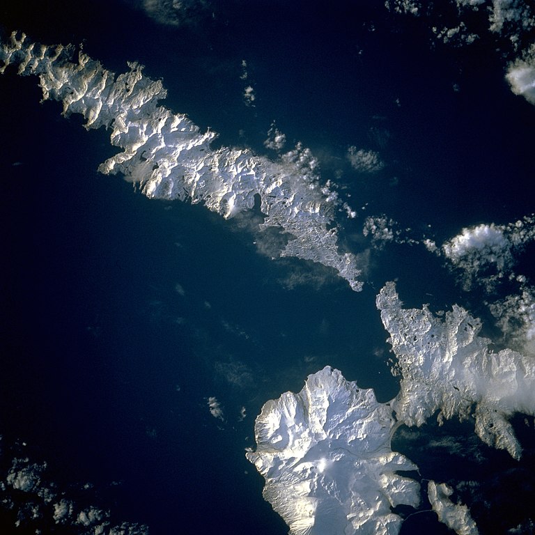
| விளக்கம் | Aleutian Islands from space A photograph of Atka Island, Amlia Island, and other parts of the Aleutian chain, Alaska. Taken on the STS-56 shuttle mission, in April 1993. Image number: STS056-071-031 The oval, snow-covered northern peninsula of Atka Island, a cluster of severely eroded stratovolcanoes and caldera, is part of the Aleutian chain known as the Central Aleutian Islands. Korovin Volcano, near the northern edge of the island, has the highest elevation on the island [5030 feet (1533 meters)] and the most eruptive activity. Elongated, east-west-oriented Amlia Island to the east rises only 2100 feet (640 meters) at its highest elevation. |
| நாள் | |
| மூலம் | http://eol.jsc.nasa.gov/sseop/EFS/lores.pl?PHOTO=STS056-71-31 |
| ஆசிரியர் | NASA |
| Camera location | | View this and other nearby images on: OpenStreetMap |
|---|
This image or video was catalogued by one of the centers of the United States National Aeronautics and Space Administration (NASA) under Photo ID: STS056-71-31. This tag does not indicate the copyright status of the attached work. A normal copyright tag is still required. See Commons:Licensing. Other languages:
|
அனுமதி
| This file is in the public domain in the United States because it was solely created by NASA. NASA copyright policy states that "NASA material is not protected by copyright unless noted". (See Template:PD-USGov, NASA copyright policy page or JPL Image Use Policy.) | ||
 |
Warnings:
|
கோப்பின் வரலாறு
குறித்த நேரத்தில் இருந்த படிமத்தைப் பார்க்க அந்நேரத்தின் மீது சொடுக்கவும்.
| நாள்/நேரம் | நகம் அளவு சிறுபடம் | அளவுகள் | பயனர் | கருத்து | |
|---|---|---|---|---|---|
| தற்போதைய | 14:43, 26 ஆகத்து 2010 | | 3,904 × 3,904 (10.69 MB) | Originalwana | higher res |
| 22:52, 4 திசம்பர் 2004 |  | 639 × 639 (307 KB) | Mschlindwein | Aleutian Islands from space |
கோப்பு பயன்பாடு
பின்வரும் பக்க இணைப்புகள் இப் படிமத்துக்கு இணைக்கபட்டுள்ளது(ளன):
கோப்பின் முழுமையான பயன்பாடு
கீழ்கண்ட மற்ற விக்கிகள் இந்த கோப்பை பயன்படுத்துகின்றன:
- en.wikipedia.org-திட்டத்தில் இதன் பயன்பாடு
- es.wikipedia.org-திட்டத்தில் இதன் பயன்பாடு
- gl.wikipedia.org-திட்டத்தில் இதன் பயன்பாடு
- id.wikipedia.org-திட்டத்தில் இதன் பயன்பாடு
- ms.wikipedia.org-திட்டத்தில் இதன் பயன்பாடு
- nn.wikipedia.org-திட்டத்தில் இதன் பயன்பாடு
- pl.wikipedia.org-திட்டத்தில் இதன் பயன்பாடு
- pt.wikipedia.org-திட்டத்தில் இதன் பயன்பாடு
- ru.wikipedia.org-திட்டத்தில் இதன் பயன்பாடு
- sh.wikipedia.org-திட்டத்தில் இதன் பயன்பாடு
- sr.wikipedia.org-திட்டத்தில் இதன் பயன்பாடு
- uk.wikipedia.org-திட்டத்தில் இதன் பயன்பாடு
- vi.wikipedia.org-திட்டத்தில் இதன் பயன்பாடு
- zh.wikipedia.org-திட்டத்தில் இதன் பயன்பாடு