
படிமம்:AfricaMap1.jpg
இந்த முன்னோட்டத்தின் அளவு: 800 × 300 படப்புள்ளிகள் . மற்ற பிரிதிறன்கள்: 320 × 120 படப்புள்ளிகள் | 1,202 × 451 படப்புள்ளிகள் .
மூலக்கோப்பு (1,202 × 451 படவணுக்கள், கோப்பின் அளவு: 101 KB, MIME வகை: image/jpeg)
| இது விக்கிமீடியா பொதுக்கோப்பகத்தில் இருக்கும் ஒரு கோப்பாகும். இக்கோப்பைக் குறித்து அங்கே காணப்படும் படிம விளக்கப் பக்கத்தை இங்கே கீழே காணலாம்.
|
| விளக்கம் |
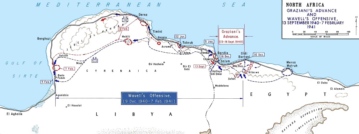
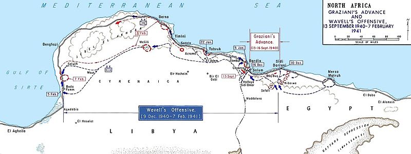
English: Graziani's advance and Wavell's offensive -- en:September 13, en:1940 - en:February 7, en:1941
Français : Avancée de l'armée italienne de Rodolfo Graziani en septembre 1940. |
|||
| நாள் | நாள் தெரியாது, after 1938 | |||
| மூலம் | Older version of Map 34 at http://www.dean.usma.edu/history/web03/atlases/ww2%20europe/WWIIEuropeIndex.html | |||
| ஆசிரியர் | Department of History at the United States Military Academy | |||
| அனுமதி (இக்கோப்பை மீண்டும் பயன்படுத்துதல்) |
|


This file was reviewed on 12 June 2009 by the administrator or trusted user Jappalang (talk), who confirmed the Public Domain status on that date.
|
Original upload log
(All user names refer to en.wikipedia)
- 2004-08-20 12:39 GeneralPatton 1202×451×8 (131506 bytes) Graziani's advance and Wavell's offensive -- [[September 13, 1940]] - [[February 7]], [[1941]]
கோப்பின் வரலாறு
குறித்த நேரத்தில் இருந்த படிமத்தைப் பார்க்க அந்நேரத்தின் மீது சொடுக்கவும்.
| நாள்/நேரம் | நகம் அளவு சிறுபடம் | அளவுகள் | பயனர் | கருத்து | |
|---|---|---|---|---|---|
| தற்போதைய | 13:52, 27 மார்ச்சு 2011 | 1,202 × 451 (101 KB) | Hohum | cleanup | |
| 13:36, 6 மே 2007 | 1,202 × 451 (128 KB) | Chanueting | {{Information |Description=Graziani's advance and Wavell's offensive -- en:September 13, en:1940 - en:February 7, en:1941 Source: US ARMY License: US Government document. Printed by the Government printing office. Assumed public doma |
கோப்பு பயன்பாடு
பின்வரும் 2 பக்கங்கள் இணைப்பு இப் படிமத்துக்கு இணைக்கபட்டுள்ளது(ளன):
கோப்பின் முழுமையான பயன்பாடு
கீழ்கண்ட மற்ற விக்கிகள் இந்த கோப்பை பயன்படுத்துகின்றன:
- ar.wikipedia.org-திட்டத்தில் இதன் பயன்பாடு
- azb.wikipedia.org-திட்டத்தில் இதன் பயன்பாடு
- bg.wikipedia.org-திட்டத்தில் இதன் பயன்பாடு
- ca.wikipedia.org-திட்டத்தில் இதன் பயன்பாடு
- da.wikipedia.org-திட்டத்தில் இதன் பயன்பாடு
- de.wikipedia.org-திட்டத்தில் இதன் பயன்பாடு
- en.wikipedia.org-திட்டத்தில் இதன் பயன்பாடு
- Military history of Italy during World War II
- Richard O'Connor
- Via della Vittoria
- Western Desert campaign
- Beda Fomm
- Military history of Australia during World War II
- Portal:Military history of Australia
- Battle of Beda Fomm
- Maletti Group
- Combeforce
- User:Ian Rose/Draft3
- Battle of Sidi Barrani
- Southern Rhodesia in World War II
- Attack on Nibeiwa
- German radio intelligence operations during World War II
- British capture of Tobruk
- en.wikibooks.org-திட்டத்தில் இதன் பயன்பாடு
- es.wikipedia.org-திட்டத்தில் இதன் பயன்பாடு
- fa.wikipedia.org-திட்டத்தில் இதன் பயன்பாடு
- fi.wikipedia.org-திட்டத்தில் இதன் பயன்பாடு
- fr.wikipedia.org-திட்டத்தில் இதன் பயன்பாடு
சிறப்பு பக்கம்-மொத்த பயன்பாடு - இதன் மூலம் இந்த கோப்பின் மொத்த பயன்பாட்டை அறிய முடியும்